An excerpt from the Safar-nama of Nasir Khusraw:
“Coming south from Syria, the first city encountered is New Cairo, Old Cairo being situated farther south. New Cairo is called al-Qahira al-Muizziyya, and the garrison town is called Fustat...
A description of the Sultan’s palace
The Sultan’s palace is in the middle of Cairo, encompassed by an open space so that no building abuts it. Engineers who have measured it have found it to be the size of Mayyafariqin. As the ground is open all around it, every night there are a thousand watchmen, five hundred mounted and five hundred on foot, who blow trumpets and beat drums at the time of evening prayer and then patrol until daybreak.
Viewed from outside the city, the Sultan’s palace looks like a mountain because of all the different buildings and the great height. From inside the city, however, one can see nothing at all because the walls are so high. They say that twelve thousand hired servants work in the palace, in addition to the women and slavegirls, whose number no one knows. It is said, nonetheless, that in the palace which consists of twelve buildings, there are thirty thousand individuals.
The harem has ten gates on the ground level, each with a name, as follows (excluding the subterranean ones): the Golden Gate, the River Gate, the Wind Gate, the Festival Gate, the Ramp Gate and the Sariyya Gate.There is a subterranean entrance through which the sultan may pass on horseback. Outside the city, he has built another palace connected to the harem palace by a passageway with a reinforced ceiling. The walls of his palace are of rocks hewn to look like one piece of stone and there are bevelderes and tall porticos. Inside the vestibule are platforms ...
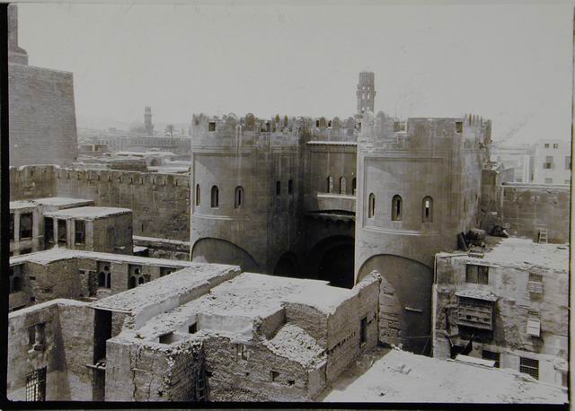
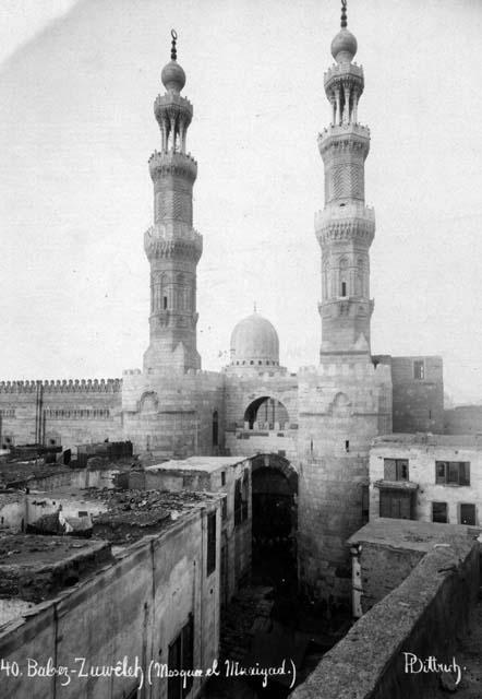
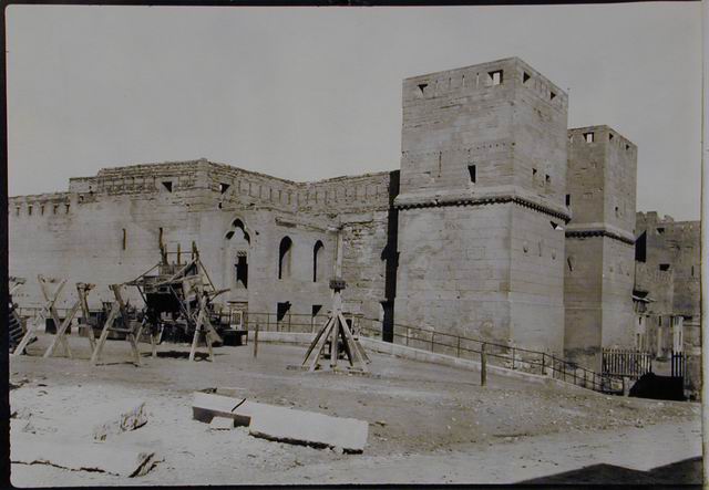
The city of Cairo has five gates, Bab al-Nasr, Bab al-Futuh, Bab al-Qantara, Bab al-Zuwayla and Bab al-Khalili. There is no wall, but the buildings are even stronger and higher than the ramparts and every house and building is itself a fortress. Most of the buildings are five stories tall, although some are six. Drinking water is from the Nile, and water carriers transport water by camel. The closer the wall is to the river, the sweeter the water; it becomes more brackish the farther you get from the Nile. Old and New Cairo are said to have a thousand camels belonging to water carriers. The water carriers who port (carry) water on their backs are separate: they have brass cups and jugs and go into the narrow lanes where a camel cannot pass...
A description of the City of Cairo (Fustat)
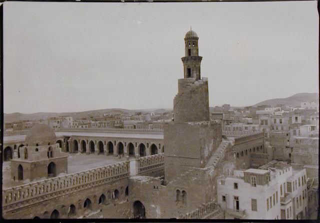
The city of Old Cairo is situated on a promontory. To the east of the city is a hill, not too high, of rock and stone. On one side of the city is the mosque of Ibn Tulun, built on a rise with two reinforced walls. With the exception of the walls of Amid and Mayyafariqin, I never saw the likes of this mosque. It was built by one of the Abbasid emirs who was governor of Egypt.The city of Old Cairo was built on a hill for fear of the Nile waters. Once the site was just large boulders, but they have all been broken up and the ground levelled. Now they call such a place an aqaba.
Looking at Old Cairo from a distance, because of the way it is situated, you would think it was a mountain. There are places where the houses are fourteen stories tall and others seven. I heard from a reliable source that one person has on top of a seven-story house a garden where he raised a calf. He also has a waterwheel up there turned by this ox to lift water from a well down below. He has orange trees and also bananas and other fruit-bearing trees, flowers, and herbs planted on the roof...”
Source: Thackston, W. Wheeler McIntosh, ed. trans., Nasir-i Khusraw’s Book of Travels (Costa Mesa, CA: Mazda Publishers, 2010), 56-67.
Being home to the treasures of Pharonic, Greco-Roman, Coptic and Islamic civilisations, Cairo is the hub of cultural and historical heritage of Egypt. Since the early military conquest of Fustat (Old Cairo) in 20 AH / 641 CE (during the reign Caliph ‘Umar) and the successive founding of al-Qahira (New Cairo) in 358 AH / 969 CE (during the reign of the Fatimid Imam-Caliph al-Mu‘izz), Egypt became the seat of power for several subsequent Muslim dynasties. After the Mongol conquest of Baghdad, Cairo became the largest Muslim city in medieval times.
Cairo from the Fatimids to Ayyubids and Mamluks: In the 4th AH/ early 10th CE century, the Fatimids established themselves as a Shia counter-caliphate to the Sunni Abbasids. In 358 AH / 969 CE, the Imam-Caliph al-Mu‘izz named the newly founded city al-Qahira, meaning 'the Victorious'. Cairo became the ceremonial residential centre for the Fatimids where the Caliph dwelt with his court and the army. The Fatimid legacy is evident today, among other things,in the al-Azhar Mosque and University, and the al-Aqmar mosque. The defensive city walls built by the Fatimids have played an important part in protecting the historic structures from encroachment by the sprawling metropolis.
The Ayyubids, who succeeded the Fatimids in ruling Egypt, adopted the Sunni interpretation of Islam as the state religion, and are said to have founded numerous public welfare institutions such as hospitals, baths, markets and facilities for trade; however, most are not extant. The citadel of Cairo founded by Salah al-Din and the sections of the walls he constructed that united the settlements of Fustat with the Fatimid Royal city al-Qahira can still be seen today. The population of Cairo also grew rapidly during Salah al-Din’s reign due to the influx of refugees fleeing from uncertain conditions in the East. Salah al-Din issued the decree that the princely enclave (of the Fatimids) should be opened to all and not reserved for the ruling class alone. These events led to considerable spatial changes in the Fatimid palatial city as the linear, orthogonal layout of the city turned into the twisting, organic streets we see today.
Mamluks ruled Egypt from 647-922 AH / 1250-1517 CE and enjoyed a period of great wealth due to Cairo’s new status as the centre of the Muslim world (upon the fall of Baghdad to the Mongols in 1258 CE), and the monopoly they were able to establish over the Red Sea trade. They constructed many large complexes, such as the madrasa and mausoleum of Sultan Qala’un, 682-683 AH / 1284-1285 CE, which is counted among the greatest architectural achievements of Muslim civilisations.
Cairo during the Ottoman rule: After the Ottoman conquest of Caito in 923 AH / 1517 CE, the Ottomans continued the construction of mosques and educational complexes in Cairo but the city lost its exalted position as the centre of the Muslim world to Istanbul. Fine architectural examples date from this period. A brief renewal of power was displayed by the Ottoman governor Muhammed Ali Pasha, who governed the city following the Napoleonic occupation of Cairo in 1798. Ottomans emulated the French city planning techniques: to open up vast new boulevards moving outward to the north and west which reconfigured the city’s spatial character. These features remain predominant in Cairo's city centre until today.
In addition to modern neighborhoods like Zamalek, Dokki, and Muhandiseen, present-day Cairo continues to encompass the historically distinct zones of Babylon and Fustat, as well as the nineteenth-century suburb of Heliopolis (Misr al-Jadida) and its contemporary counterpart, al-Ma’adi.
Citation:
“Cairo” Encyclopedia of Islam. Second Edition. 2013 http://referenceworks.brillonline.com/entries/encyclopaedia-of-islam-2/al-kahira-COM_0417?s.num=0&s.f.s2_parent=s.f.book.encyclopaedia-of-islam-2&s.q=al-kahira
Bloom, Jonathan. Arts of the City Victorious. (New Haven: Yale University Press, 2007).
Steele, James, ed., ‘The Significance of Cairo’, in Architecture for Islamic Societies Today, (London: Academy Editions: London, 1994).
Bab al-Futuh
http://archnet.org/sites/2180 [accessed February 2014]
Bab al-Nasr
http://archnet.org/sites/2727 [accessed February 2014]
Bab Zuwayla
http://archnet.org/sites/2728 [accessed February 2014]
Ibn Tulun Mosque Restoration
http://archnet.org/sites/6096 [accessed February 2014]
"Islamic Cairo". UNESCO World Heritage Website.
http://whc.unesco.org/en/list/89. [accessed June 2013]


